 Walks and other things
Sa Tuna, Cap de Begur, Begur
 Costa Brava") This is one of the classic senderismes (walking routes) of the Costa Brava around the cliffs and bays of the Cape of Begur. It's almost all GR92, but the path from Sa Tuna up the hill across the hilltops is steep and feels quite close to the cliff edge. Begur (pronounced Begu in Catalan, the r doesn't sound) is both the name of the village of Begur that stands high on the hill with a castle and fort with commanding views around and across the Empordan plain, and the name of the area of the Cape of Begur. The Cape takes in the sub-villages or Sa Riera, Aiguafreda and Sa Tuna and a number of other estates and areas in between. The Cape itself rises from sea-level at the beaches upto heights of about 250m and is therefore very hilly and up and down, and by the coast is a collection of bays, soaring cliffs and woody hillsides. It is possible to walk the whole Cape in one day, but now we prefer to take it more piecemeal as there are lots of climbs and lots to see. In the past we might have started at Begur and walked down, but we've found starting at the low point and walking up in the first half of the walk when we have most energy gives us a downhill for the second half which makes the walk more rewarding.
This is one of the classic senderismes (walking routes) of the Costa Brava around the cliffs and bays of the Cape of Begur. It's almost all GR92, but the path from Sa Tuna up the hill across the hilltops is steep and feels quite close to the cliff edge. Begur (pronounced Begu in Catalan, the r doesn't sound) is both the name of the village of Begur that stands high on the hill with a castle and fort with commanding views around and across the Empordan plain, and the name of the area of the Cape of Begur. The Cape takes in the sub-villages or Sa Riera, Aiguafreda and Sa Tuna and a number of other estates and areas in between. The Cape itself rises from sea-level at the beaches upto heights of about 250m and is therefore very hilly and up and down, and by the coast is a collection of bays, soaring cliffs and woody hillsides. It is possible to walk the whole Cape in one day, but now we prefer to take it more piecemeal as there are lots of climbs and lots to see. In the past we might have started at Begur and walked down, but we've found starting at the low point and walking up in the first half of the walk when we have most energy gives us a downhill for the second half which makes the walk more rewarding.
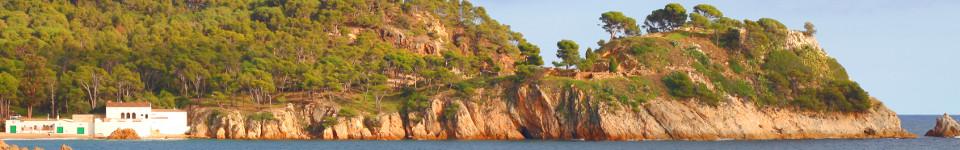
 We start at the beach at Sa Tuna, a charming pebbly bay surrounded by a small collection of old-style fishermen houses and restaurants ('Sa' would have been local dialect catalan for 'La' - you see something similar in 'Ses' which would be more conventionally 'Les'). After the relatively cold and wet weather recently it's a little bit of a surprise to see the first sunbathers in bikinis on the beach, as we're still in long trousers.
 The path from Sa Tuna wraps up behind the beach towards the headland/penisula to the right. This is a GR92 path, so follows the red-white flashes and it's fortunate that we are looking for them, otherwise we would have walked right out to the peninsula when actually the path climbs into the woods to the right. to begin with it's relatively easy, but it steepens just under a viewpoint marker, with the cliff to the left not so far away, and turns into more of a scramble on loose soil/stone (for safety good footwear is a must). The view from the marker looks back over the bay of Sa Tuna and around to the relatively ugly large hotel at Cap Sa Sal which is out of keeping with the surroundings (but probably has great views from inside).
 The viewpoint though is only really about halfway up and the path continues to climb up through the scrub and bracken. You can't help but realise that the cliff face to the side is rising too, but the path is just sufficiently far away from the edge that you don't see the drop except in one or two places. Over the crest, the path becomes more wooded but still on the sea-side of the hill. At one point in the woods someone has installed a stone picnic table and bench right on top of the cliff with views out to the sea. I didn't take the opportunity to see how high up it was.
Back through the woods and the path emerges on a road in a sparsely populated estate. Large individual houses seem to cling to the hillside just to have a sea view. We walk on the road, but there is no-one around and the path soon heads back into the woods. As we walk we almost step on a small grass-snake sunbathing in the May sunshine. It ignores us completely and doesn't move as we stare at it.
 The path climbs through the woods and we get the first glimpse of the lighthouse/military station perched on the point of Cap de Begur. We reach a road at the top of the path - a viewpoint is marked to the left down towards the military station (which as we find seems disused). At one point there are views to the south down to the watchtower above Llafranc and across to the beach at Aiguablava and round to Fornells. There are scattered dots of people on the sandy beach at Aiguablava and the first yachts in the bay. Close to the military station are views to the north along past the Isles Medes and up to Roses and beyond.
The path becomes a road through another luxury estate before climbing out along a ridge in the direction of Begur and Tamariu. At the top of the gentle climb the route splits. The main GR92 turns to the left across a high hillside above the sea covered with yellow gorse and other flowers in pinks and whites. We take the GR92 as far as the next viewpoint. This is even grander than the two before. From the top you can see all the way down the coast past Palamos to Torre Valentina past St Antoni de Calonge. The GR92 from the viewpoint down is a long steep climb and having done it once we're not that keen on doing it again, so instead of continuing with the GR92 we double back and take the route to Begur itself.
 We're still on road and we walk to the outskirts of Begur village with views of the gardens at the back of the grand Indianer houses with their murals and mosaics sitting underneath Begur's castle. At one point you can see three or four of the medieval defensive towers, plus the church all peaking above the general hubbub of houses of the village. Begur centre is known for the grand houses (Indianers) built by Catalans who had made their fortunes in the 19th Century out in Cuba and the Carribean. It holds a Festa de Indians every year when the whole town seems to dress up in whites for food, drink and music on the (packed) streets.
From the town itself there are options as to how to return to Sa Tuna depending on how long a walk you want to take. We take the 'classic' way down the Cami Vell de Sa Tuna. This is the old road, but is now really a track that runs above, below, across the modern tarmac road as it zigzags down the hill. The Cami Vell is quiet and relatively straight and we pass behind houses and fields on the way down.
At the bottom close to the junction split for Aiguafreda/Sa Tuna, the path runs straight down past a no-entry sign into a network of houses. Steps take you down to a stone-built walled path that runs along the side of the bay looking out across Aiguafreda. It's marked with a cross for the GR92, but it seems new and you can follow it around the headland overlooking the sea and back to Sa Tuna.
Neighbouring walks: Masos de Pals, Begur, Sa Riera and Platja de Pals - Fornells and Aiguablava walk (GR92) - Palafrugell, Tamariu, Begur residential and Esclanya - Begur, Ses Negres and Sa Riera
Swimming and canoeing: Swimming and canoeing at Sa Tuna (Begur)
Events: Begur - Festa d'Indians


Comments