 Walks and other things
Tossa de Mar to Cala Llorell
 Tossa de Mar is one of the most popular destinations on the Costa Brava for holiday makers who come for the beach, the castle and old town walls that almost seem to tumble into the sea, and the busy bars and restaurants that run along the back of the two main beaches.
We've walked to the north (towards Cala Pola) and from the south on the GR92 from Lloret. This walk takes us down to Cala Llorell - the next beach to the south of Tossa de Mar.
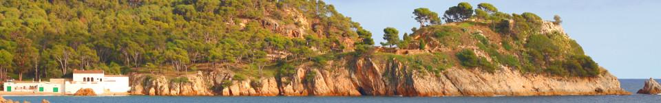
A grumble for the GR92 from Lloret is the way the path passes across the top of some of the estates away from the beaches and coast itself. This can be for practical purposes, such as a lack of access for a beach framed by cliffs at one end, but also a number of the beaches have almost become private estates, fenced off and with a single point of access from the top with the route for walkers often a dull fence lined path through the hills at the back, without obvious diversions or routes down to the sea. Cala Llorell is case in point, and was one of the few beaches on the Costa Brava we still hadn't visited, so this was a bit of an explore south from Tossa.
 Our first problem was that Tossa de Mar on a May Day weekend was full of visitors, though the beaches were still pretty empty as we're not quite into swimming season yet. However, it did mean that the car parks were very busy, so not being afraid of a little walk, we parked on the outskirts by the sports centre and walked along the stream path into town.
The roads through town were jammed - fine for browsing and strolling in the spring sunshine, but a little too slow for what we wanted to walk. So instead of taking the route to the old town and the castle and then up over the hidden pretty beach of Codolar and the Cami de Ronda, we nip through the quieter backstreets up to the top path.
 The top leads to some spectacular views from the Mirador de Codolar high on the cliffs over the town and there were plenty of people making the walk to take in the view. We carried on out though, joining the GR92 through the pine woods as we climb up and away from Tossa de Mar. The path is broad and gravelly and well used.
At a point just after the Xalet Vermell (the Red Chalet) - so called because it's a small red house and the only real feature on the path, the path splits. The GR92 turns to the right and the path down to Llorell continues downhill towards the sea. The path is fairly plain through the trees, but you have to be careful to keep to higher paths to the right - marked with arrows - as the routes down to the left are all dead ends.
 The path emerges into the campsite of Camping Cala Llevado which takes up a huge part of the hillside. In fact the campsite looks excellent with large amounts of terraced spaces and some quite luxury looking wood cabins around. To get down to the beaches though you have to walk on the roads through the campsite. In May this is not a problem, but in the height of summer, access may be more restricted for non-campers - something to check.
For our initial path we just head straight down for the first beach, down a long stretch of steps marked out with wood to a very small (and in summer naturist) beach at the bottom. All the way back up and then around the road to the pretty double-bayed beach of Cala Llorell. This beach is backed by a beach-club bar with an estate of houses dotted around the hillside to the back feeling like a private club-type resort. The sand is the same gritty sand of Lloret and Tossa and is split by a rocky outcrop in the middle. We could see a third smaller beach at the far end with a walkway around the cliff, but didn't go that far around.
 Coming back we took the main campsite road up to the top and the main entrance (just opposite a rugby ground). This is back to the GR92 which for this part across the top of the campsite follows the main Lloret to Tossa road. On the first path off, the GR92 turns into the woods and after a while we find ourselves back at the Xalet Vermell.
Instead of repeating the route back, we take the first left after the Chalet down into the woods, following the stream making for a very pleasant descent through the woods with new leaves on the trees. Above us we can see the Torre de Moriscos - the Moor's Tower. The path emerges at the back of the main car parks for Tossa close to the bus station and would be an option for walking avoiding the centre of Tossa and the route by the cliffs.
See also: Tossa de Mar north to Cala Pola - Lloret's Platja de Boadella, Platja de Santa Cristina and The Fence - Blanes, Lloret de Mar, Tossa de Mar by GR92 - Sant Grau and Cadiretes near Tossa de Mar - Llagostera to Sant Llorenç - Sant Feliu de Guixols Pedralta
Swimming and beaches of Tossa de Mar

