 Walks and other things
St Antoni de Calonge, Torre Valentina to Platja d'Aro (almost)
 Platja d'Aro and St Antoni de Calonge (which runs into Palamos, so is sometimes referred to as being part of Palamos) are two neighbouring package-holiday type resorts, both with big flat beaches and high-rise hotels and apartment blocks. Neither look too inspiring for walking. But in actual fact between the two, around the cape of Torre Valentina are a series of small sandy bays (cala) and rocky headlands including some of the most photographed beaches of the Costa Brava. This is also part of the GR92 path.
 We start in Sant Antoni de Calonge. There is an older heart to Sant Antoni, but it's now dominated by the more recent buildings and we actually park out towards the supermarkets (and tourist office) close to the main roundabout that links the Calonge road to the main Palamos to Platja d'Aro road. We head straight for the beach and there is a steady stream of people and families out for a Sunday stroll, some of them carrying palm-leaves for Palm Sunday. And though it's the start of the Easter holiday, there are relatively few foreign holiday makers about.
 The passeo route along the beach in front of the hotel and apartment blocks passes over a metal bridge then on and past the Hotel of Torre Valentina. Around the hotel you can also see two original torres, one in the grounds of the hotel and the other on the headland. With all the modernity around, it's easy to forget that in the 1500s this was an area under frequent attack by the Barbary pirates (part of the Ottoman Empire navy that dominated the Mediterranean sea in the same epoch that the Spanish were dominating the Atlantic to the Americas) . Watch-out towers and defences were essential against the raiders.
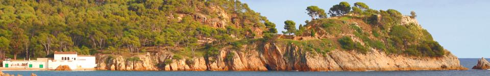
 As soon as the path turns past the hotel it climbs over the headland and its character changes completely. Instead of the vast holiday-sand, there are rocky coves with pebble beaches that run into crystal clear water. The path follows the headland and then passes the tower Torre Valentina itself. The tower is connected to the hotel and has been restored, but access is only possible from the hotel itself. The path turns under a small road and head is the first of the many little bays and beaches. This starts with a series of flat rocks that stretch out into the water (Roques Planes), with a small sandy beach. We cross the sand to reach a series of steps and another small headland. Then again another sandy cove.
 Eventually we reach the first of the larger sandy bays. Along the path are a series of sandy bays and beaches. The beaches themselves are all linked to campsites (these are Treumal, Calonge International and Cala Gogo) and we see the first campers, mostly in caravans or motorhomes in the choice spots close to the beach. In the summer there is limited parking near to the beaches except for the campsites, so for the most part the beaches are used by campers or those willing to walk a little to find a better beach.
 At the end of the third bigger beach we run into the first problem. The GR92 path is closed due to landslides and storm damage. This happens relatively regularly, but often by the time Easter comes the path is renovated and passable. On this path at several points where the official path is closed, it can be possible to work your way around the headland over the rocks, but the sea has a swell and we don't want to risk it. Instead we follow the alternative path back up to the main road and then look for the next connection to the next beach.
 This means passing Hotel Cap Roig - a hotel with direct access to the bay. We find the path down and find ourselves on the absolutely empty beach. The beach itself is one of the most photographed on the Costa Brava as it has a small red island/presque isle at one end which means a beach with two sides. With the sky overcast and the chance of rain, the beach itself is totally empty.
 We check the path back to where we should have come from, and railing are missing and the sea swell is pounding against the rocks. So instead we try to continue to Platja d'Aro along the beach. In theory it's just another couple of small bays along, but once again the path is closed due to rock falls/storm damage.
Instead we find the stairs out which take us up and out by Hotel Sant Jordi - the second of the fabulously well placed hotels on this stretch.
The one downside to this route is that it's pretty much a one-way route - the route back is either along the road, or back the way we came along the bays. For completeness and speed we take the road route which means you can see just how big the three campsites are. Calonge International even has it's own bridge over the road. By Treumal we come off the main road and through the backstreets of modern apartment blocks and holiday homes.
Neighbouring walks: Platja d'Aro and S'Agaro - Calonge (Cami de Molins and over Cabanyes) - Calonge into the Gavarres - La Fosca to Palamos - Platja Sant Pol to Sant Feliu de Guixols
Swimming: Swimming at beaches between Platja d'Aro and Sant Antoni de Calonge - Swimming and beach at Platja d'Aro - Swimming and bay of St Antoni de Calonge
Update: Some parts of the walk that were closed have been repaired and re-opened (July 2014) with a new walkway in the parts that washed away, so it should be possible to complete the walk without having to go back up to the road.
Update 2: The final final parts of the walk that were still closed are now fully open (October 2016) with the path in a much better condition between Cala de Pi and Platja d'Aro. One little detail is that at the end of Cala Belladona beach the path is still a little confusing as there look as if there are three potential sets of stairs out of the beach - two straight ahead and one to the right. The ones straight ahead are closed - take the one to the right it leads to a path around the headland to the next beach.

