 Walks and other things
Begur, Ses Negres and Sa Riera
 Begur is a popular area for people who come to the Costa Brava for walking. The town is on a hill which forms part of a headland that juts out into the Mediterranean leading down to a series of bays and beaches, such as Sa Tuna, Sa Riera or along to Fornells. It is possible to walk the entire headland in one go, but as we mentioned in the walk for Sa Tuna to Begur, our preference now is to make smaller loops, partly because the walks tend to be quite up and down.
We've included Begur twice so far - the walk from Masos de Pals to Sa Riera via Begur, and the walk from Sa Tuna to Begur and back. This is effectively the missing bit of the triangle and takes us down to the coast along the Ses Negres Maritime Nature Reserve before returning via Sa Riera.
The first part of the walk to the Mirador de la Creu is largely a flatish walk from Begur centre into the woods and then gives fabulous views over the coast up towards L'Estartit and Roses, the Pyrenees and over the bay of Sa Tuna/Aiguafreda.
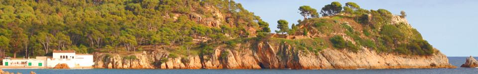
We start in the municipal parking just by the Parc d'Arbreda below the main part of Begur town, then wind our way through the back streets part some of the old mansions built by returning Catalan tobacco and sugar barons who had made their fortunes in the Carribean, to the start proper at the second junction of the circumval.lacio road that runs around the bottom of Begur town, just below the castle. Being the start of February, the weather can get cloudy and we have an overcast day, but despite that the views from the top are spectacular and we can still see all the way along the bay of Pals and Pals beach, beyond Montgri and up the coast to Roses and to the left we can just see the snow on the Pyrenees peaking out from behind the clouds.
 The walk we're taking is marked with green-white flashes and is one of the routes that is included on walking maps of Begur from the tourist information centre (senderismes). Having said that, a signpost would still be useful at the start and return points as you do have to look out for the green-white flashes.
Leaving the town and the first small urbanisation we are quickly into the woods on a broadish track with an easy relatively level walk. The woods have signs of quarrying and stone extraction, but just make for a pleasant wooded walk. The flashes take us along a smaller track and we emerge on a quiet road by the first signpost. We have the option of going down towards Sa Riera, or a gentle upward slope to the Mirador de la Creu.
We go up to the Mirador to start, knowing that we will have to double back down. The mirador itself has parking nearby for those who aren't walking, and consists of a rocky outcrop on top of the hill which requires a half-scramble to get up. The views extend around almost 270 degrees, with Pals Beach and onwards to the North and the back of Aiguafreda/Sa Tuna beneath us to the south.
 Having taken our fill of the view, we return along the road we came up, but this time we continue down towards the coast past the scattered holiday villas that have been built along the road. Bizarrely though the road is practically empty, there are old broken and rusted street lights all the way down. At the bottom we run into more houses and have the option of either heading down to Aiguafreda and Cap Sa Sal, or continuing around the hill to Ses Negres and we opt for the second option.
The road continues to curl downwards along the side of the hill and though we are walking on tarmacked road, it's quiet with no vehicles at this time of year. As we get lower, the green-white flashes indicate a side road to the left which at first glance looks like a dead-end. In fact there's a set of stairs that run past a house being built (technically the path was closed, but we ignored it - it'll be open again by the summer).
At the bottom of the stairs, we are on a concrete path with a small wall that runs above dark red/black rocks that stretch down to the sea 10-20m below us. These are Ses Negres - the black rocks - an unusual colour and shade for this part of the Costa Brava and almost orange like the Algarve in places. The area is a maritim nature reserve and we can see cormorant fledglings sitting on the rocks with their parents. We can see the Isla Medes up the coast and right across the bay we can see the Isla Roja and Platja de Pals.
 The path curls around the coastline, then returns to the road just behind some large sea-side villas with infinity pools looking out to sea. After a short bit of road-walking, the path returns to the rocks - you have to take care to look out for the green-white flashes as the signpost has been knocked down - and loops around to a small sandy bay by the side of the main Sa Riera beach. It's winter now and Sa Riera is largely closed up, but in summer the beach has dozens of small fishing boats lined up on the sand and holiday makers on the beach.
We walk through the couple of streets of what was a small fishing village before heading up the road past the newer holiday homes that have been built. We're looking for the footpath by the stream back up to Begur, and it's not very well marked unless you know what you're looking for (it's the same path we came down for the Masos de Pals-Begur walk). We have to head out on the road as if we're going out and then the second track to the left has the green-flash on the stop sign. This takes us along a track to the back of some houses and we continue up the steps at the end and across what looks like someone's garden - don't worry this is the right way.
 After the garden we have the stream to our left and the path follows the stream all the way back up to Begur with a series of small cascades and rockpools as we go up. At various points there are steps and the occasional deep well shaft for when the river runs dry. The only complication is crossing the road a couple of times, where you have to look for the green-white flashes to know where to continue - basically still along the stream.
The route is up all the way, but it's a steady climb so not too arduous and being by the stream there are trees and grass areas, though it is quite long, emerging at the top by Parc d'Arbreda again.
Neighbouring walks: Fornells and Aiguablava walk (GR92) - Sa Tuna, Cap de Begur, Begur - Masos de Pals, Begur, Sa Riera and Platja de Pals
Swimming: Swimming and beach at Sa Riera (Begur) - Swimming and canoeing at Sa Tuna (Begur)
Events: Begur - Festa d'Indians

