 Walks and other things
La Jonquera to Fort de Bellegarde (France)
 La Jonquera is a border town just below the main pass in the Pyrenees that separates France from Spain. This pass has been used for thousands of years by peoples moving between the Iberican Penisular and mainland Europe. The Roman's came this way and built the historic Via Augusta road that runs all the way through Spain down to Cadiz and links with the Via Domitia on the French side of the border.

With such a long history and with such strategic importance, both sides have built castles and forts to defend the border. As you drive along the modern autoroute if you look up, you'll see Fort Bellegarde - a Vauban chateau fort built in the 1690s after France annexed Catalonia North.
The road itself was also important as it was the main route out of Spain for tens of thousands of Republican refugees fleeing Spain at the end of the Spanish Civil war. La Jonquera has the museum of exile which states that at one point La Jonquera had around 500,000 people in the town looking to flee into France.

Nowadays, La Jonquera is a brash shopping area for day-trippers from France coming to stock up on perfume, wine and cigarettes at the Spanish lower tax rates, and as a truck holding stop with artic lorries from across Europe parked up to avoid the French restrictions on when truckers can be on the road. As you drive past it's not obvious that there is an older town hidden behind all the gaudy supermarkets, advertising and petrol stations.
The idea for the walk was from our children who were thrilled with the idea of walking to France (and we did take passports just in case). Despite being a Sunday, La Jonquera was busy with cross-border tourists out for a bargain and it was the Festa Major in town, so we had some difficulties parking. We eventually found space on the south side of the town, which meant we could walk through the centre to see more of the town on our way north.
 The Via Augusta route is one of those suggested on the Costabrava.org website and we were looking out for yellow-blue marking. These, together with scallop shell symbols, mark the Route of Saint James (Camino de Santiago) which connects all the way to Santiago de Compostela in Galicia. Unfortunately where we started from we couldn't find the symbol, and the marked walking routes and maps in the town tended to be more circuitous routes into the hills longer that we planned.
So instead we followed our nose through town. The centre had decorations up for the festival and a line of ladies making lace with needles on cushions and dozens of bobbins linking threads to make the patterns. The centre is small but has older buildings and a church and is very pleasant for a stroll. We continued through the town past the numerous clothes and souvenir shops including a big pile of mexican sombreros - something which isn't really Spanish, let alone Catalan.
Eventually we started to come out of the town and it still wasn't clear where to go. Outside the customs house, the main road split to the main motorway or the N II - neither of which we wanted to walk along, and ahead of us was an large empty expanse of concrete that presumably would have been used to hold trucks before the border was opened under Schengen. We guessed and crossed the concrete and just the other side of the last town roundabout finally saw the first yellow-blue marking. The path itself didn't seem that well used with gorse and brambles growing across the track. However, after the first stretch we crossed the NII and under the motorway and started across the fields towards the hills.
 The path now ran through fields with the motorway on one side and the new AVE high speed train line on the other. At the end of the fields the path joins a road that leads up to the service buildings for the new Pyrenees train tunnel into France. Our path continued up and over the top of the tunnel following a track that climbed steeply into the woods.
Last year (July 2012), a huge forest fire that burnt a stretch of woodland and forest nearly 40km long from the border back down almost to Figueres, and so much smoke that that it reached Barcelona. We drove past about a week after it happened and it looked like total devastation - with every tree seemingly caught by the fire and left as black leafless sticks as if nothing had survived. Now walking through the woods you see the resilience of the corks trees and the forests. The fire has cleaned out the undergrowth, but the woods are back to green as new plants have grown. And the cork-trees with their blackened bark are back in leaf. Foresters are clearing out the genuinely dead trees, but the thing with cork-bark is that it is a fire protection. Only the very outer part of the bark burns and as cork bark continues to grow from the inside out, slowly the damaged outer bark is rejuvinated by the bark underneath. It's the same principle that enables cork to be harvested by stripping the bark from the tree, without damaging the tree itself as the bark grows back.
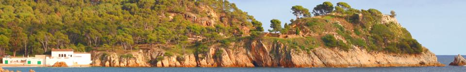
 We climb steadily past large boulders and rounded weathered rocks. Ahead of us we can see the fort, but also a strange tower-house which looks like it has a face. We carry on following the marked signs up to Col de Panissers and arrive at the ruins of the Roman fort built on the col. As we look around the fort and read the description of the ruins we're not entirely sure if we've crossed the border, but we discover that the pyramid just above the ruins marks the border so we can stand one foot in Spain and one foot in France. The sign on the ruins marks the change of road from Via Augusta into Spain to Via Dolmitia into France. To the north are great views down the Vallespir valley and onwards to the plains of Roussillon and the Corbieres mountains in the distance. Behind up we have a view that looks all the way to the Montgri hills.
Above us is the main fort that can be seen from the autoroute - Fort de Bellegarde so we walk up to the fort itself. The fort is one of the Vauban forts like that of Villefranche de Conflent and Mont-Louis further up in the Pyrenees - a large dominant fortification built after the annexation of Catalonia north in the seventeenth century with thick walls and remparts and few comforts. It stands above the main autoroute and we can look down at the crossing point with lorries passing over the now open border. The town beneath us is Le Perthus - distinguished by being half in France and half in Spain with the border running straight down the middle of the main road.
We take the chance to explore the fort a little. Many of the rooms are now used as galleries displaying paintings and sculpture but it still feels like an indomitable castle. In the tower on one corner is a deep deep well that was the main source of water. The height of the walls and the castle's position means there are fabulous views in all directions and down to the former border, but it is a harsh building with few comforts - perhaps in keeping with it's history as a prison used by the Gestapo in the Second World War.
Though we prefer circular walks, the route back to La Jonquera mostly takes us back the same route as we came up - a slight diversion around the military cemetary links to the same path down to the top of the AVE train tunnel with views along the tracks down towards Figueres. At the bottom of the path, rather than follow the overgrown route we had discovered with difficult, we take the Pyrenees 8 Bike path along the side of the railway and motorway which is more open and rural and follows a stream back under the railway and motorway and back into La Jonquera and the mad stream of cars and people bustling around the cross-border supermarkets.
Neighbouring trips: Day trip to Villefranche-de-Conflent and Mont-Louis in France - Espolla to Rabos - Perpignan - Elne (France) - Ceret (France) - Mollo (Camprodon) Pyrenees to France - Figueres and Castell de Sant Ferran - Waterfall at Les Escaules (Boadella) - Sant Pere de Rodes - Portbou to Cerbère (France) and back - Castell de Requesens
