 Walks and other things
Portbou to Cerbère (France) and back
 Portbou and Cerbère are villages that link the Costa Brava to the Cote Vermillion, and until the AVE/TGV line under the Pyrenees, were the ends of the railway lines for Spain and France respectively, joined by a tunnel, but where passengers and goods had to change because of the different track gauges.
The coast road itself is also served by road, but with a string of hairpin bends and curves is the slowest road way into Spain, popular only with mobilehomes and motorcyclists looking for a tour.
So, while we have driven this route a couple of times, and passed through the villages, from the road they are small and somewhat undistinguished, so it's an area that is mostly off the beaten track except for the intrepid.
 However, by train the journey is only 40 minutes from Flaçà, and although the road route is about 7km between the towns, there is a short 3km walk over the hills to link the two. So we headed out for the day - and just loved it - definitely one of our favourite explores.
 Now this might seem strange, the towns aren't big, they have massive railway siding yards and constructions, they've fallen into a bit of disrepair, the beaches are grey grit and pebbles so not the first choice for a beach, and the hinterlands are steepish stone and rocky terraces into the hills.
But there's something captivating in the almost industrial qualities of the towns with a beach and the touching history as a crossing point for refugees - from Spain to France in 1939 and from France to Spain in 1940, and a sense of loss as transport and traffic moved to other routes. There's almost something cinematographic about the towns and locations and plenty for photographers to discover (though our day was a little misty for photos).
 The first indication of this almost lost grandeur, is arriving at Portbou station. It is enormous - a long steel arched construction similar to Estacio França in Barcelona, with shades of Paddington or Sant Pancras in London.
In the 1930s to 70s, this would be a point of change for passengers as they disembarked from France to change trains to continue the journey on to Barcelona, Valencia or Madrid, checked by customs officials and passport control for the onward journey.
 Even goods had to switch trains, giving work to the town to facilitate the changing goods, the paperwork and exports agents.
So the station dominates the town. Even the church - just next door to the station - was built for the railway workers. And it sits between two tunnels - out to Cerbère or south along the coast towards Figueres - tunnels that go under the hills that the cars have to go over.
So when we arrive, the first thing we note is just how big the station is, but also how quiet and empty for such a large space. You can feel the missing people as you walk to try to find an exit. Something made more difficult by the renovation works around the station and a total lack of signposting.
 Leaving the station, we look down to the town and out across the sea. Portbou is not a large town and it's a five minute stroll down to the beach, but since we're exploring, we see a sign to the "WB Memorial" with an indicator for a viewpoint.
WB we find out, was Walter Benjamin, an important Jewish philosopher of art from Germany known within the circles of Berthold Brecht. In 1940 he arrived in Portbou with Jewish refugees fleeing the Nazis. However, his party was stopped in Portbou by Franco's Guardia Civil and told they would be deported back to France. Fearful of the terror that awaited, Benjamin took his own life a day after arriving in Portbou.
 The memorial itself was our second eye-opener. It sits next to the town cemetery on a space on a headland where you can look back to the town and the beach. The memorial itself is a flight of stairs in an oxidised steel tunnel that looks straight down to the crashing waves of the sea giving a beautiful spooky feeling of light, darkness and movement from the water. Taking the steps to the bottom, you still only see the sea, but looking back up you have a stairway to light at the top.
From this moment we knew we'd found a gem of a town for visitors looking for something different. From the memorial we walked back down to the beach area. It's October so even if there were sunbathers, there wouldn't be too many around, but two older ladies are taking a dip in water that looks cold under the grey skies. Out in the bay a snorkeller in a wetsuit and flippers is prowling the deeper waters.
 The main leisure port is around the corner under the monument headland, hidden out of view but not so special, so we turn back along the beach promenade and the handful of closed bars and restaurants to the one place we can see that's open - a chirguito behind the beach with 8-10 rainbow gay flags fluttering above it some of which have a Canadian Maple Leaf on them - we've no idea why.
Still exploring, and not yet on the walk, we walk along the town rambla and read the signs describing the Retirada (the Retreat) of when, at the end of the Spanish Civil War, people from Catalonia and further south fled the victorious Franco Fascists through Portbou. As a main supply line into Republican Spain, Portbou was a target for air attacks by the Spanish forces.
 At the back of the rambla, the road leads to an enormous tunnel that we couldn't fathom to start with. It's huge cavernous interior with a road and river, that we discover looking down from above the town, has the railway sidings above - so needing road access - while allowing the river to take the water from the hills behind the town to the sea.
Coming back out of the tunnel and just about to start our walk, we then see the sign for a "Pamtomataria" above a restaurant. It takes a while, even for our fluent Catalan speaking daughter, to realise this is a "Pa amb Tomate - ria" - bread with tomato and olive oil being one of the traditional foods of Catalonia.
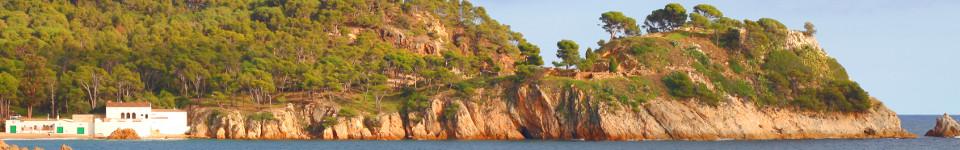
And so we started to walk up the hill. It is only 1km to the top of the hill and the French border. Initially, the path follows the streets in the town, but it emerges as a stone track route in the final few hundred metres.
 At the top we have views up and down the coast, with Cerbère's mass of railway tracks down below us. There is a small memorial to the Retirada at the top, with collections of photographs of the Spanish exodus as they passed the customs post, and into France, where they were taken into the refugee camps at Argeles-sur-Mer.
Just below the top of the hill we have to cross the road as it passes through the old French Douane post, now totally covered in graffiti. It's not entirely clear where the route down to Cerbère goes so we take the road for a bit until we find the sign. If you're walking, you can take the route at the back of the white customs post building which connects to a yellow signed path on the road below.
 The path down to Cerbère runs down a gully with terraces on the other side of the hill presumably once as vineyards, now looking like they are cultivating cactus.
Towards the bottom of the path we pass a rusted old car that must have fallen off the road above many years ago and is now stuck and abandoned.
The gully reaches the town below and runs under the railway lines and then along a huge wall or embankment built to support the tracks above. Cerbère's town is dominated by the size of these supporting walls built in brick and arches.
The road at this point, is like a dry concrete river bed with the houses and pavement higher up and steps down to the road with small bridges over the top. This is typical of drier places where the road will become a river if there is enough rain, but on the majority of the year it can be used for cars and parking.
 The road takes us to the centre and almost immediately we're on the horseshoe of shops and restaurants above Cerbère's beach almost immediately feeling like we're in the centre of town. Now everything is in French with a typical French brassiere overlooking the bay.
The beach, like the one in Portbou is grey grit and pebbles, and not so inviting, with a port across the bay with huge concrete blocks acting as sea protection. This is an area were the tramuntana wind can blow fiercely with gusts over 100km/h not uncommon on a windy day. The sea also can get rough, and hence the size of the groins and protections.
 There are further notices and exhibitions as the end of the Retirada. But the view from the French side is more complex, as this is also the crossing point for French, Belgium and German refugees fleeing the Nazi regime in the 1940s. And later in the war, also a route for people smuggling such as downed Allied airmen. Escapers could take one of the hill paths, or would attempt to walk directly through the railway tunnels at night.
As one of the obvious crossing points it was manned directly by the Gestapo, and unlike the Spanish refugees, getting caught could be fatal.
We walk up the road by the sea, and walk around the white hotel built above the railway line in an art deco style. It's quite striking for its location and style.
 We do visit the station because if the walk is too much, it would be possible to catch a train back through the tunnel with a train every hour for the short tunnel link. However, besides picking up a couple of leaflets and looking at the timetables with trains on to Narbonne or Avignon, the station itself is nowhere near as impressive as Portbou.
 Leaving the station, we want to get back to the other side of the tracks, and we see a subway to the left that looks like it might curve under the tracks. Inside it is crudely lit and long, filled with lurid coloured graffiti which might make it unsettling at night. As it turns we get our third tunnel surprise of the day, because ahead of us we can see directly to the beach with the sea straight in front of us.
 For the walk back we decide to take the coastal path. We follow the road out along the headland until it reaches an open space with a small lighthouse. From here a path runs up long the cliff of the hill behind. I'm not keen on high drops, so I scramble a route up a little more inland, while the others stay to the main path. At the top it connects back to the customs crossing and we can make our way down into Portbou, and back to the train - 40 minutes and we're back in Flaçà. Great day out.
See also
Villefranche-de-Conflent and Mont-Louis (France) - La Jonquera to Fort de Bellegarde (France) - Mollo (Camprodon) Pyrenees to France - Puigcerda and Bourg-Madame - Perpignan - Elne (France) - Ceret (France) - Collioure (France) - Castell de Requesens (Cantallops) - Llança - Port de la Selva - Cadaques and Port Lligat - Sant Pere de Rodes

Comments | ||
Visitor: 213.205.194.92 |
29 Aug 2021 10:21 |
|
Sitting at the seafront in Port Bou while I wait a train to Cerbere and onto Narbonne and Beziers. Lovely to find and read your article. I'd do the walk if I didn't have luggage!! Jules x | ||
